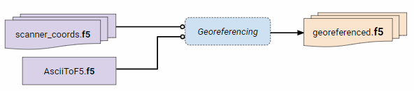
This converter transforms coordinates in the scanner own coordinate system to world coordinates in the according UTM coordinate system.
Needed input are two .f5 files: the point cloud in scanner coordinates and the trajectory in world coordinates.
All world coordinate systems according to the EPSG standard are possible.
All needed .f5 files should be places in the input slot.
Make sure the GPSTime range of the trajectory exceeds that of the point cloud.
The algorithm is based on following paper:
"Rigorous Strip Adjustment of AIrborne Laserscanning Data Based on the ICP Algorithm"